
Lafayette LA
Updated 2-27-2025
Originally Published 2-19-2025
After a frontal passage that brought rain to the area the Dredge the Vermilion’s (DTV) Boards Text Group became very active after the following comment-question was posted by a board member:
” Question the river climbed from 5 plus feet to over 9 feet in last few hours. Explanation? Not enough rain so I’m thinking tidal or ?”
Another board member has been tracking rainfall amounts in inches vs river rise in feet at Surrey gage for years. He has reported about 1″ of rain usually equals about 1FT rise but noted it seemed to be getting worse in recent years.
So, the investigation began. Immediately the suspect was Coulee ill Des Cannes(CIDC) and it’s effect on the river
A board member who lives near the Lafayette – Vermilion Parish rain reported 1.5″ in his rain gage.
Investigating the rainfall at the Lafayette Airport gage we found the below – only 0.94″ of rain.
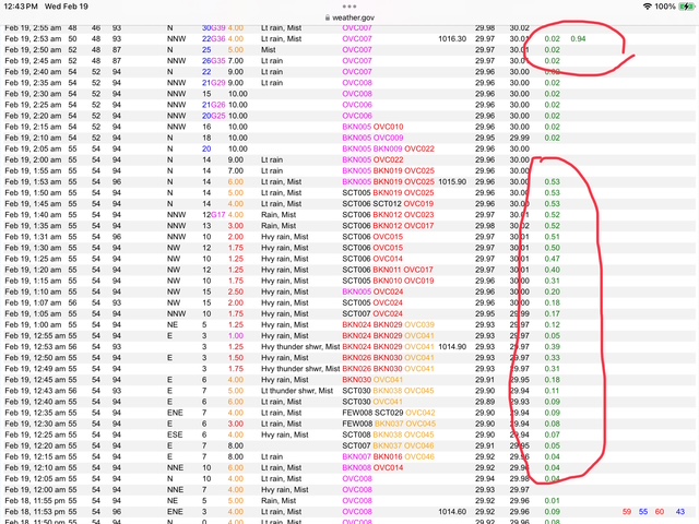
Rainfall-at-LFG-Airport-2-19-2025
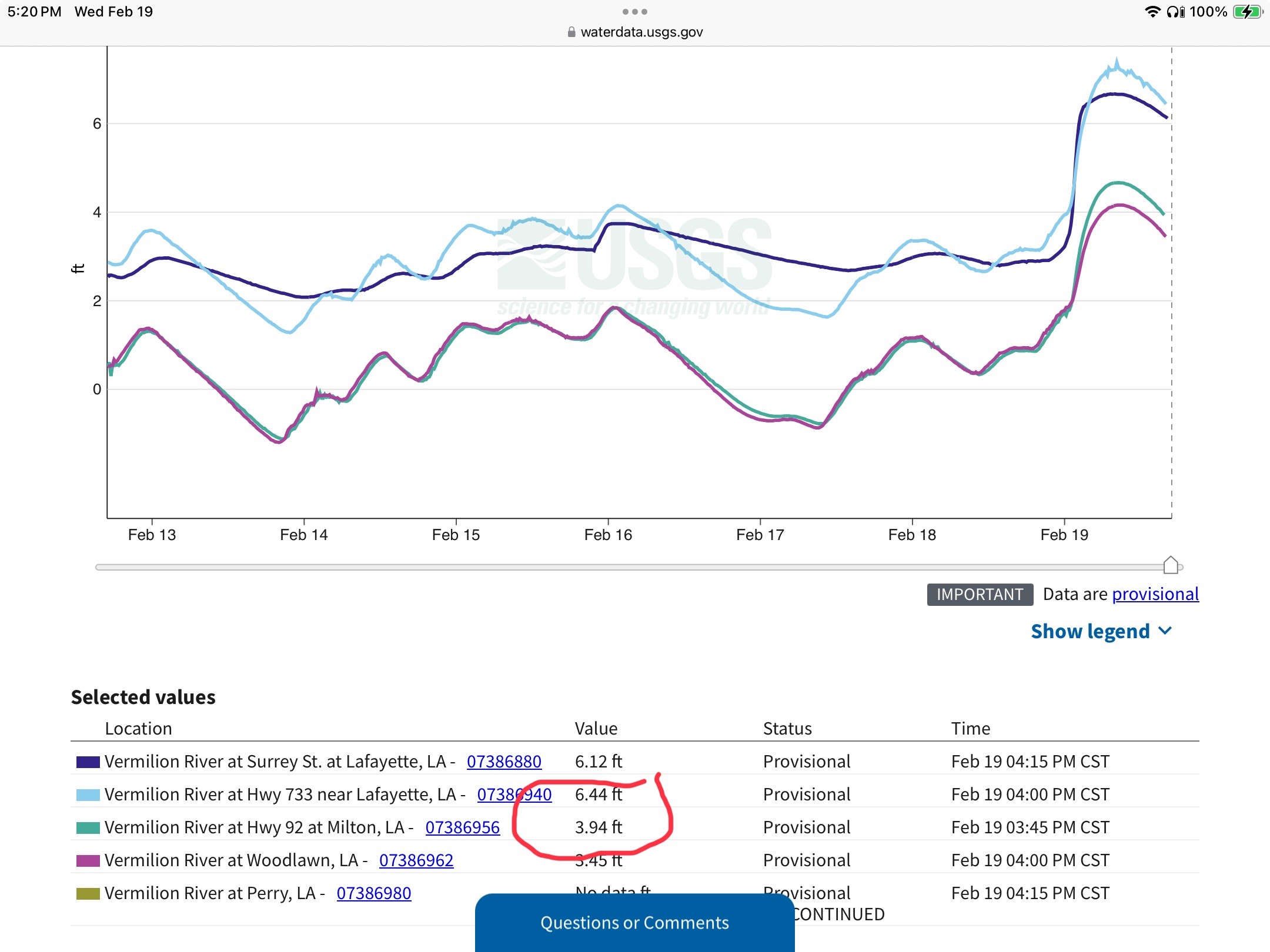
Suspecting that drainage south is being blocked probably by CIDC we began checking USGS river gages. NOTE- in below graph the level is higher at E Broussard than at Surrey when river crested. Water CANNOT flow uphill so again points to the CIDC effect on the river. This is the effect we have documented when a large rainfall in the CIDC watershed begins blocking drainage south in the river.
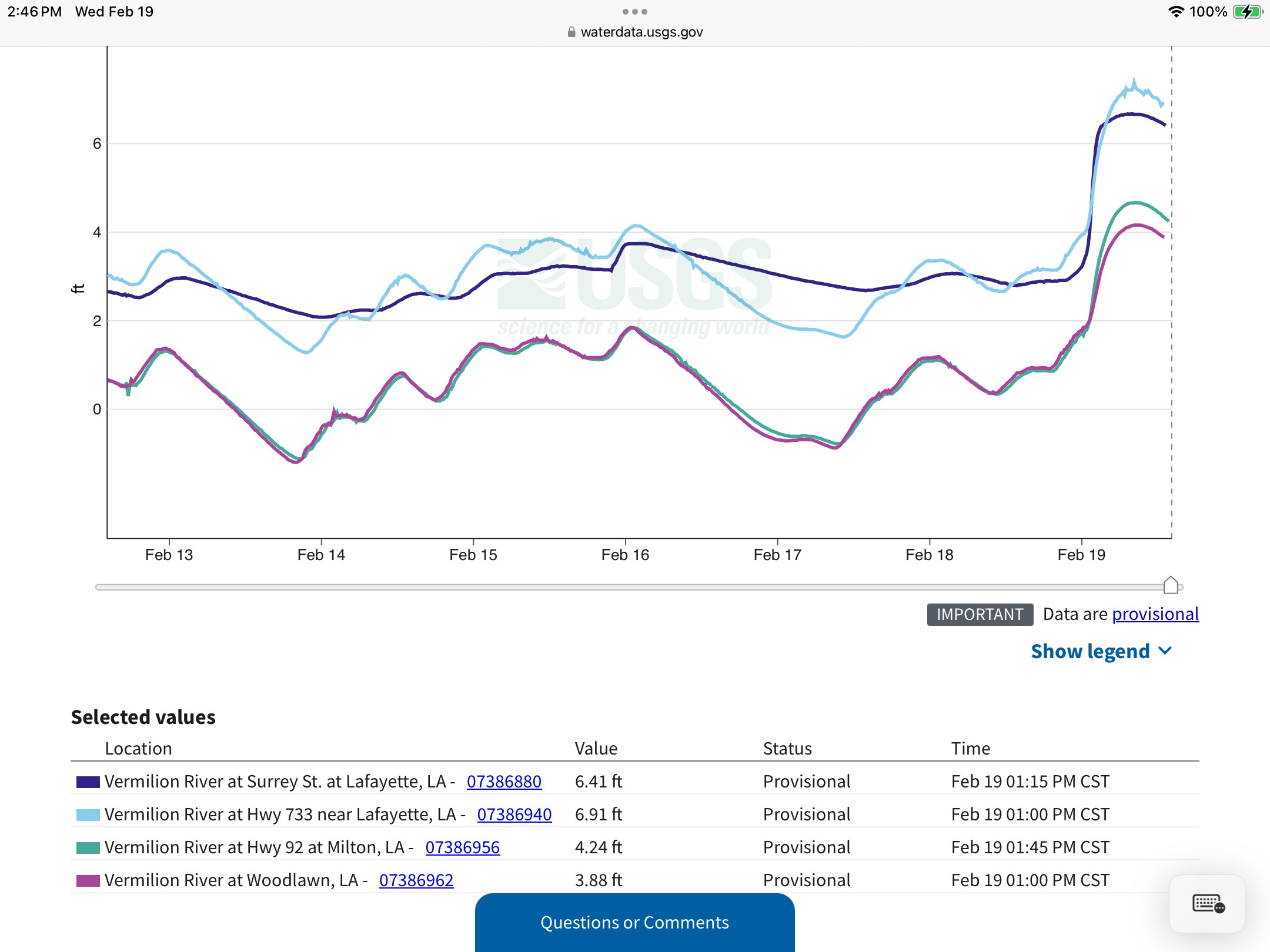
Graph of Levels along the Vermilion River 2-19-2025
We also took a look at tidal effect and the data appears minor effects with a north wind during frontal passage so this is ruled out as a cause of this dramatic river rise.
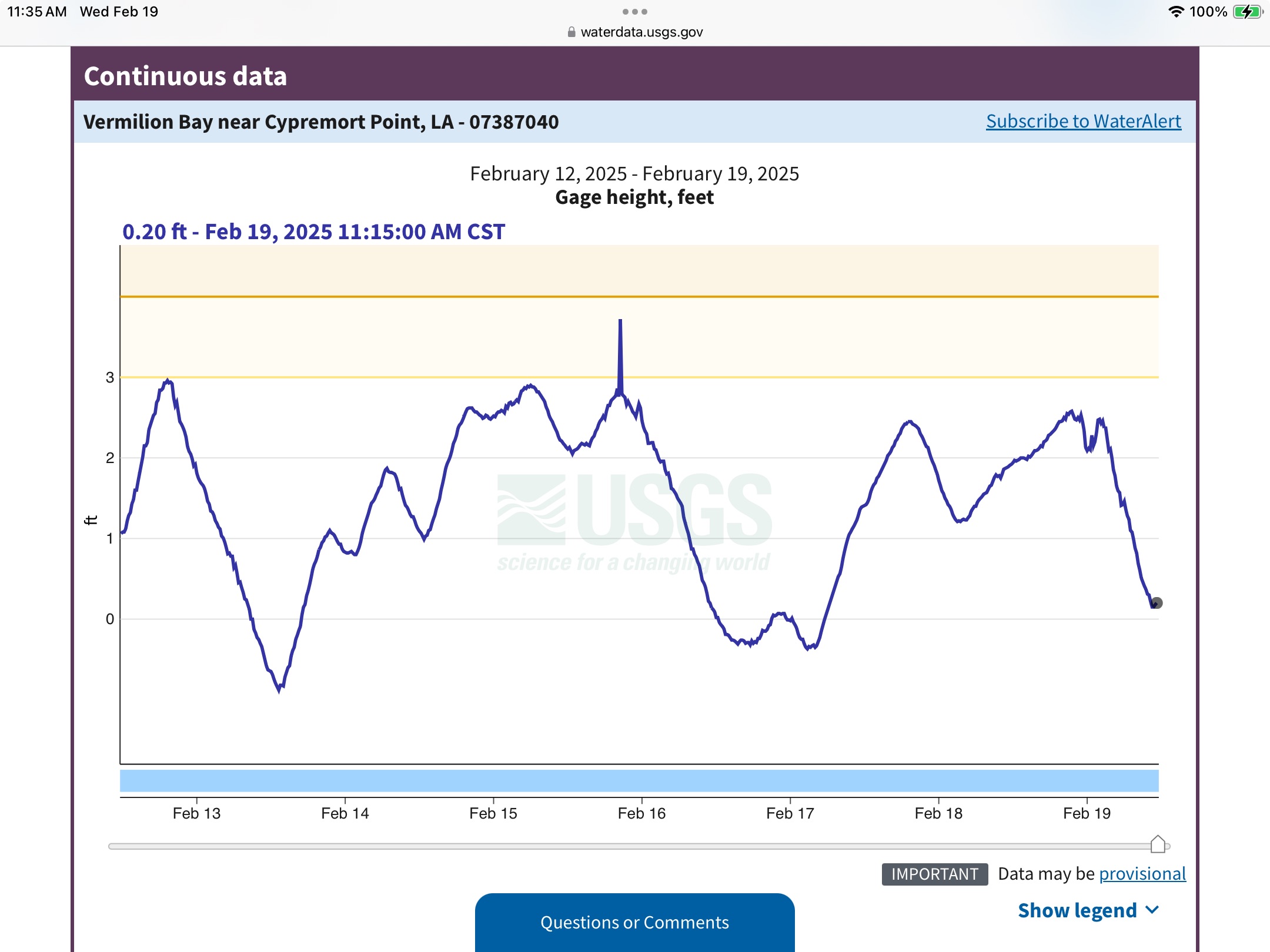
Graph of tide at Cypremort Point in Vermilion Bay 2-19-2025
Another board member posted the following question – ‘Did the Scott area get a heavier downpour than the rest of the Parish?”
An investigation in rainfall in the upper CIDC watershed uncovered the following data:
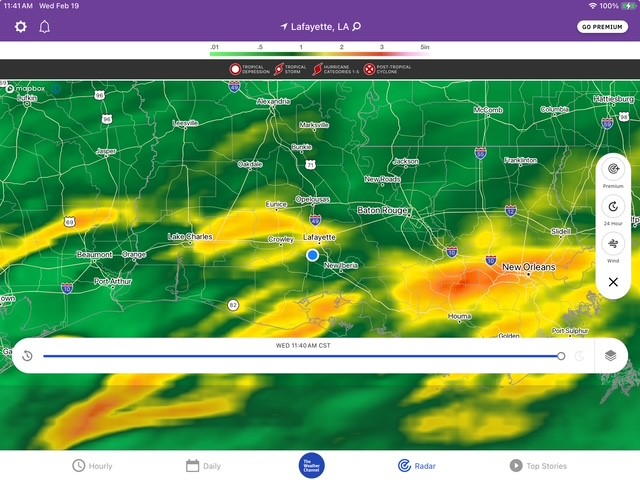
Radar-Estimated-Rainfall-2-19-2025
Note the area north of I10 and North of Scott received a heaver rainfall than surrounding areas. We then looked for confirmation using the WeatherUnderground web weather system which allows the public to connect their private weather stations to their database.

Weather Station near Osson LA 2-19-2025
The above weather station reposted about 2.5″ of rain in the Osson area. Another private weather station near the Wetlands Golf Course near Carencro East of Scott. reported 2.47″
Next the flows at Surrey gage were investigated to see if a North Flow (reverse flow) happened during this event.
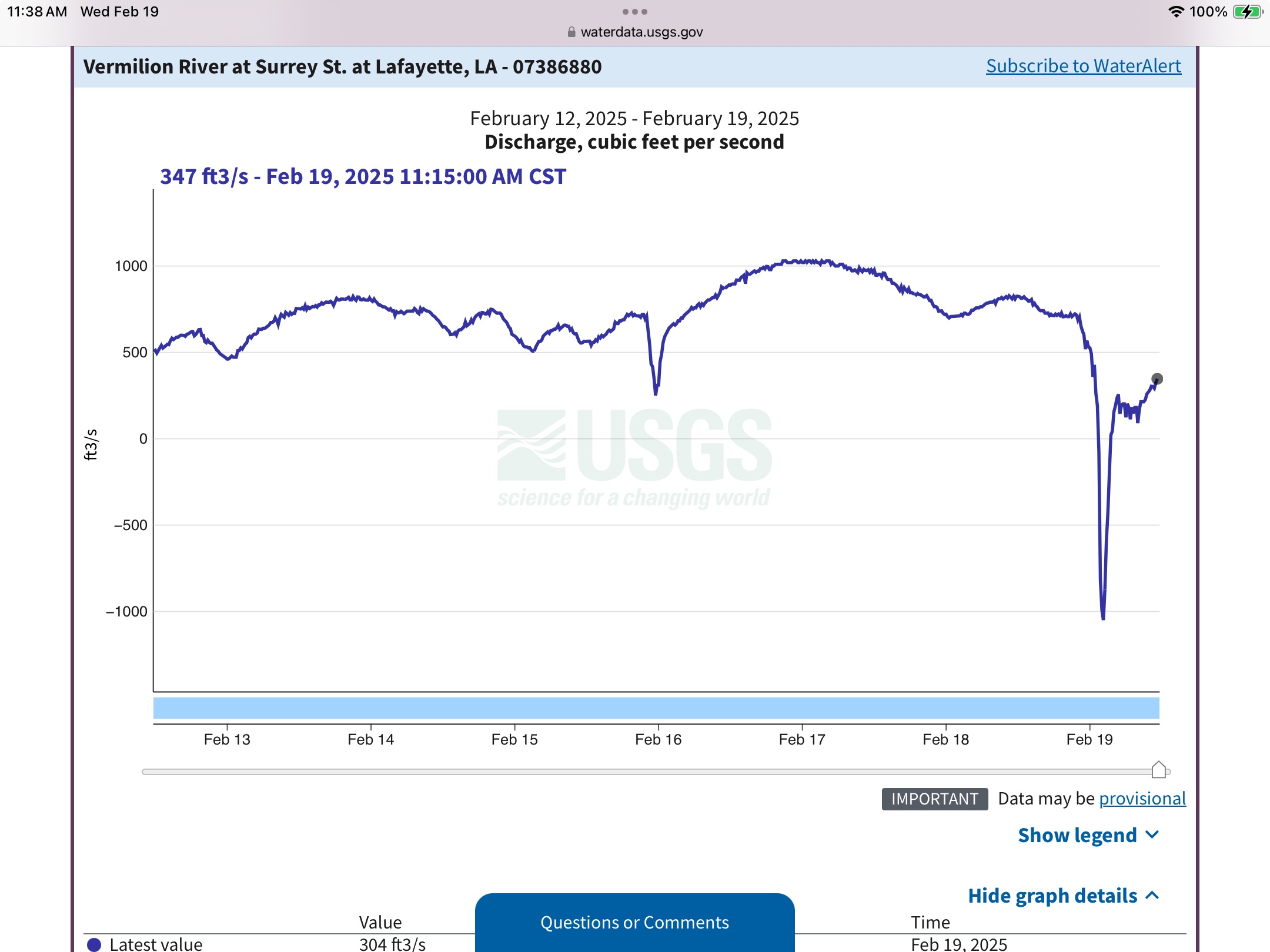
Vermilion-River-at-Surrey-St.-at-Lafayette-LA 2-19-2025
Note the Surrey Flow graph above. Also note the sudden and extreme change in direction to north and flow ultimately exceeded 1000CFS North. Our analysis is a mini-flash flood causing the river to rise so quickly and it appears this flash flood happened in the northern CIDC watershed and NOT in Lafayette proper.
Then we conducted some visual surveillance along CIDC and took the following pictures.
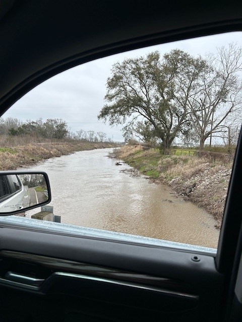
CDIC-near-Scott-2-19-2025
CIDC near Scott was high and flowing south strong.
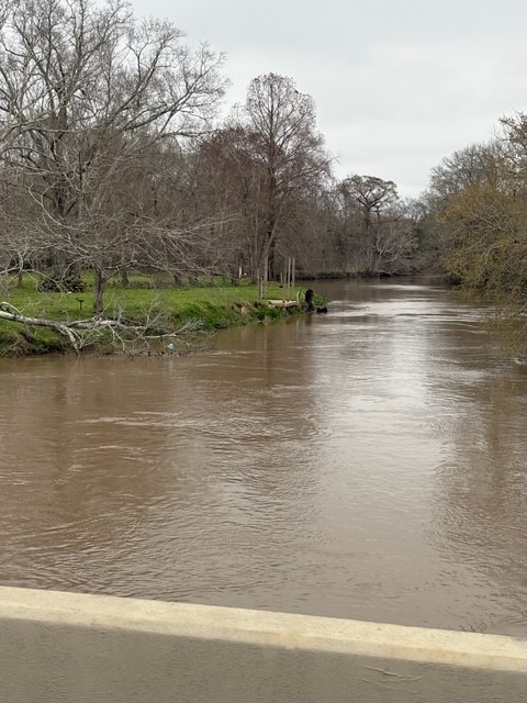
CDIC-at-Robley-Kirk-Rd-2-19-2025
CIDC was flowing strong and near bank full at the last bridge before coulee flows into the river.
Additionally, we looked at flows in the river at Surrey and Milton when Surrey resumed flowing south to the Gulf.

Note that Surrey was flowing south at 751CFS vs >3000CFS at Milton and Milton peaked at 3740 CFS when river crested. The Ruth Canal gate is closed so all Surrey flow is from north VR watershed minus what is coming in at the Fusilier Weir near Arnaudville.
So, another look at levels along the river during this event illustrated the following that the river was measuring 2.5′ higher at E Broussard than Milton. Upon further investigation it appears that the NAVD88 Stream Level calculations for the Milton gage may be in error as this differential exists even during low water normal pool stage readings. We recommend investigating this issue See below graph.
LA733-2.5FT-higher-then-Milton-2-19-2025
Executive Summary
While it’s customary to place an executive summary at the beginning of an article we wanted to present the above unmistakable hard evidence of the threat CIDC presents to the Lafayette community. During 2016 flood the highest water levels recorded between the Cypress Island Swamp near the airport and Vermilion Bay were at the CIDC -River confluence. Even a 2.5″ rainfall event rain in northern CIDC watershed produces measurable and visual evidence of the threat CIDC presents. The rain event on 2-19-2025 is a great example of the effect of CIDC on the Vermilion River. A second event on 2-22 and 2-23 with a nominal 2″+ area rainfall pushed the river to a minor flood crest of approximately 10.6′ at the Surrey gage on 2-23-2025.
In addition, one board member who is a retired engineer noted the following ” They may have moved sediments that built a higher and larger dam down steam (in the river). I do not think this rain should have caused CIDC to force considerable water up stream without an increase in blockage downstream”. Also, there may be trees in the river or tree debris caught in the Milton bridge structure that cause a 2.5′ difference between LA733 and Milton when the river crested. We recommend investigating the gage and or NAVD88 calculations accuracy at Milton and potentially a survey be conducted between CIDC and Milton to evaluate this observation if the gages measurements are found to be accurate.
It is imperative we urgently pursue completion of the Vermilion Flood Control Projects to de- risk this threat. The threat CIDC presents risks another major flood to the Lafayette, Maurice, and Cypress Island Communities if it’s flood flows are not adequately dealt with reducing the effects on the Vermilion River. Additionally, we recommend that development of properties in the CIDC watershed employ even more stringent retention requirements.
𝐀𝐛𝐨𝐮𝐭 𝐃𝐫𝐞𝐝𝐠𝐞 𝐭𝐡𝐞 𝐕𝐞𝐫𝐦𝐢𝐥𝐢𝐨𝐧
Dredge the Vermilion (DTV) is a non-profit setup to inform the public about the need to identify and to perform regional drainage projects in the Teche-Vermilion watershed.
The board of DTV are all citizen volunteers with varying backgrounds from engineering, business owners, business management, medical, and legal.
If you wish to help with our efforts please like and share our posts on Facebook(search “Dredge the Vermilion”) and please see our website at www.dredgethevermilion.org if you would like to make a donation. All donations help fund our website, Facebook, and other marketing efforts, public outreach, and research.