
LCG Public Works has submitted a permit application to execute a spot dredging project of the Vermilion River at the confluence of the river to Coulee Mine near Rotary Point. You can access the Public Comment section for the project which includes detail and drawings regarding what the parish is proposing at the following link.
LCG Permit
I submitted a public comment expressing support of the project. Below is a copy of my comment.
“Dear Ms. Oestringer,
Please be advised that I fully support this project. Severe shoaling in the river near the confluence of coulee Mine and the river increases flood risk to the area as well as contributing to wetlands destruction in the nearby Cypress Island swamp.
The swamp is a natural flood plain for the river. The river, which is tidal, typically flows north during a flood event with this water entering the nearby swamp due to the close proximity of the swamp to the city and lower elevations in the swamp. After the flood drainage to Vermilion Bay is slowed due to the shoals in the river increasing the amount of time the swamp stays underwater. This situation causes increased risk if a second storm happens before the swamp drains as much of this natural retention volume is already used up. Additionally, the extended times the swamp is under flood is contributing to the destruction of wetlands as this is harming hardwood in the swamp and destroying smaller vegetation that provide low browse food and cover for wildlife.
Additionally, I have been advised by US Rep Clay Higgins staff that the USACE executed a spot dredge around 1997 in this same area after a near major flood event in 1993. Residents who have resided along the river before and after this 1997 project reported fewer high water events where the river overflowed its banks into their yards after a rain event after the project was completed.
If you would like to contact me regarding this matter, please note my contact info below.
Regards,
Dave Dixon
President Dredge the Vermilion, Inc.”
If you wish to submit a Public Comment concerning the proposal you can make a Public Comment until Dec 3 2022, by emailing:
[email protected]
Please reference – Application #: MVN-2022-00201 WQQ
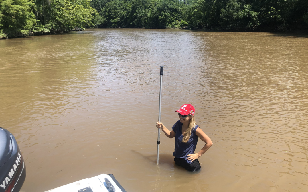
The photograph in this post illustrates the severity of the shoaling in the river near Coulee Mine. At the time and date (July 4th, 2020) of the photo the gauge at Surrey Steet was reading approximately 6.00ft or about 3.25ft above sea level. At this water level if the river channel was at the authorized depth the water would be greater than 11ft deep.
𝐀𝐛𝐨𝐮𝐭 𝐃𝐫𝐞𝐝𝐠𝐞 𝐭𝐡𝐞 𝐕𝐞𝐫𝐦𝐢𝐥𝐢𝐨𝐧
Dredge the Vermilion (DTV) is a non-profit setup to inform the public about the need to identify and to perform regional drainage projects in the Teche-Vermilion watershed.
The board of DTV are all citizen volunteers with varying backgrounds from engineering, business owners, business management, medical, and legal.
If you wish to help with our efforts please like and share our posts on Facebook(search “Dredge the Vermilion”) and please see our website at www.dredgethevermilion.org if you would like to make a donation. All donations help fund our website, Facebook and other marketing efforts, public outreach, and research.