
5/28/2025
Lafayette LA.
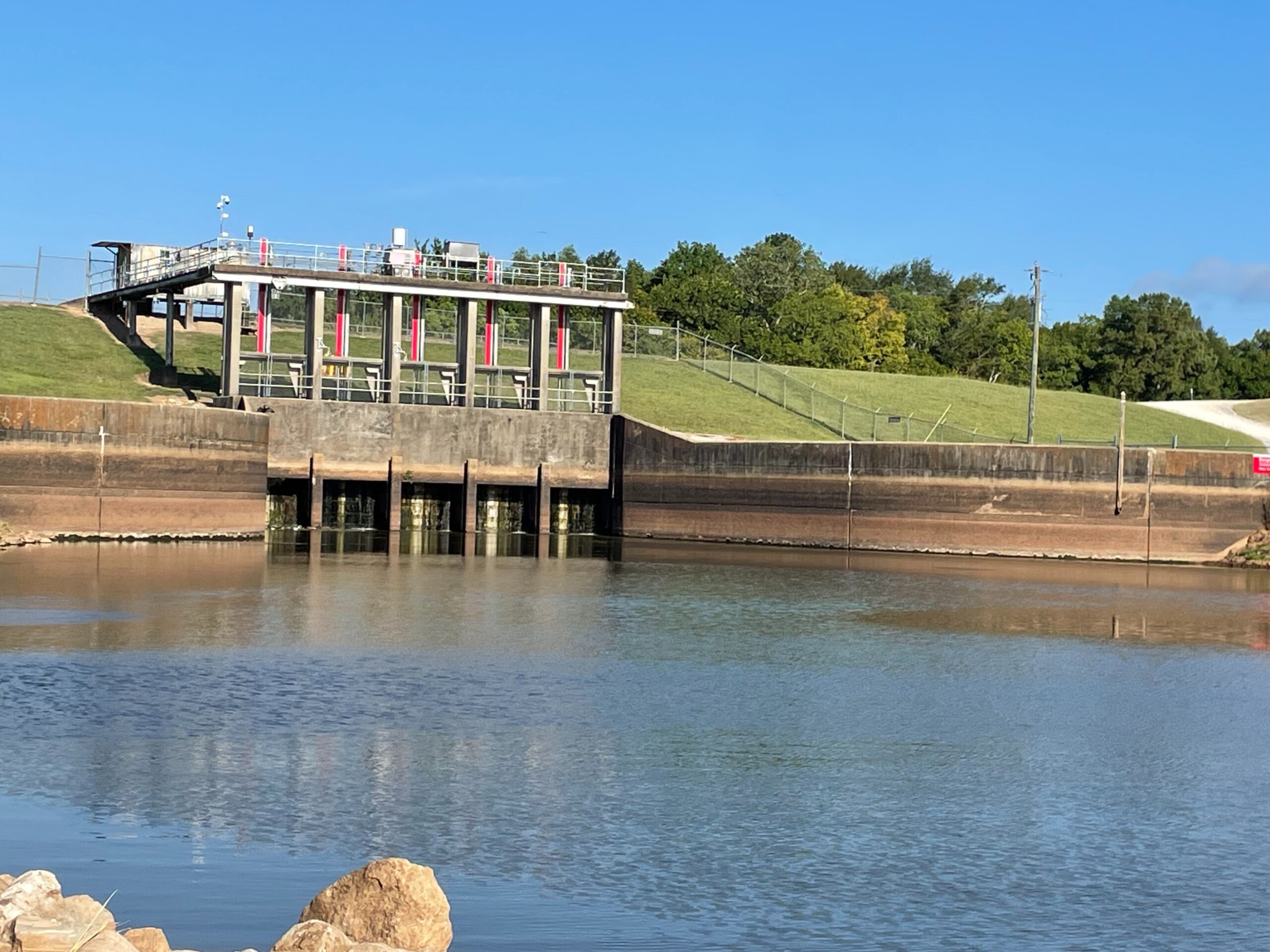
This article will address the reasons why the water in the Vermilion River is staying high so long. The floodgates in the picture above are on Bayou Courtableau at the West Atchafalaya Floodway Levee and their role in flood management are mentioned below.
After the April 2025 flooding events we have been asked why the Vermilion River is staying so high so long. There are a number of reasons why this is happening. Unfortunately, some of the information in this article is somewhat technical so we will try to explain this in language that can be understood by the public. This article also contains links to supporting and more detailed information regarding specifics areas in the watershed, issues, and systems identified or referenced in this article. We recommend reading the entire article first then exploring the more detailed information for a better understanding of the watershed and our drainage issues.
The reasons include:
- We have had a fair amount of rain starting towards the end of March. There have been 5 separate rain events that caused a NORTH flow at the Surrey gage starting March 29th.
- This, along with rains north of Lafayette parish, have kept the Cypress Island Swamp (aka Bayou Tortue Swamp) at a high level. The swamp is a giant overflow area (floodplain) for our watershed. During a past flood some years ago weather conditions were right to conservatively calculate an estimated retention volume utilizing the Surrey gage for the swamp. There is an additional lesser drain of the swamp called the Joe Dage canal but no gage data is available on that canal so this was not considered.
Here are some numbers – in the graph below values less than 0 are flows north to the swamp and numbers greater than 0 are flows to south to the Gulf:
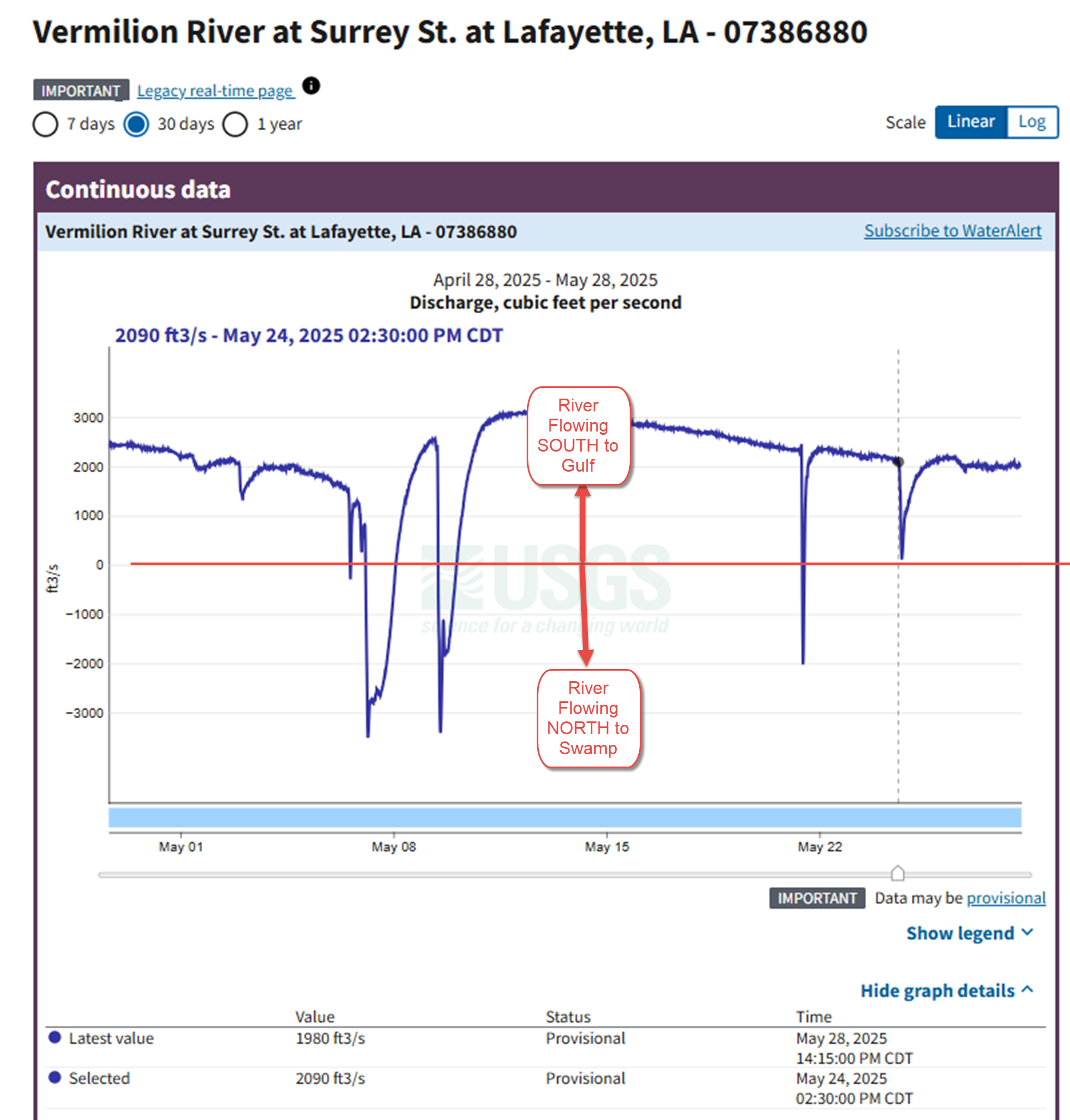
Surrey-Flow-gage-illustrating-North-and-South-Flows
We conservatively estimate the swamp to have greater than 100,000 acre/feet of retention when full at about 14′ on the Surrey gage. For perspective, this is greater than 156 square miles covered with 1ft deep water! Because the Vermilion River is the only drain South to the Gulf, other than the Joe Dage Canal, it takes some time to empty this area. Other issues impact the ability of the river to move this water south including:
-
- Shoals in the river act that like dams slowing the drainage. We estimate that maintenance dredging the river to authorized dimensions would accelerate the drainage by 30-35%. So, after the river exceeded flood stage at 2am May 7 and remained above flood stage until May 22 around 11am, or 15.4 days, a major dredging project should reduce that to about 10-10.5 days. This assumes the blocking effect Coulee Ill des Cannes (CIDC) has on the river is also adequately dealt with -see below. Periods of time that the river remains above 8ft or so at Surrey increase the risk a second rain event before the river falls back to normal levels will cause a flood.
- Tides – high tides slowing the flow south
- Coulee Ill des Cannes sometimes creates a water dam for a period of time after a large rain that completely blocks the river’s ability to drain south to Vermilion Bay
- Rains north of Lafayette back fill the swamp. Teche Vermilion Freshwater District (TVFD) reports rainfall at their pumping station in St Landry Parish North of Lafayette. Since April 1st they have reported 14″ of rain!
- Other floodplain swamps in St Landry Parish also receive floodwaters and this water has to be drained to reduce the risk after a flood event. Note: If you have traveled I49 North of Washington LA after a big rain you might have noticed water flooding the land along the Interstate where the highway traverses through the swamps. All of these swamps ultimately drain into Bayou Courtableau which drains to the southern area in the watershed including Lafayette, St Martin, Iberia, St Mary and Vermilion Parishes.
- Additionally, Bayou Courtableau receives floodwaters from the northern part of the watershed including Rapides, Evangline Avoyelles, and St Landry Parishes and these waters also need draining after a flood. A large portion of this water is drained through the Vermilion River. There are no flow gages on the Bayou Courtableau gates or Bayou Amy,
- However, on the 2 tributaries where gages are installed, the typical flows measured after a flood event like the recent event show that the Vermilion River typically drains 50%+ MORE than the Bayou Teche.
The US Army Corps of Engineers (USACE) operates floodgates on the West Atchafalaya Floodway Levee (pictured above). These gates can, and have been open, recently in an attempt to limit the amount of floodwaters that reach the lower land side of the watershed including Lafayette, St Martin, Iberia, and Vermilion Parishes. However, this gate drains to Lake Pelba and Lake Henderson which are experiencing high levels due to the Atchafalaya River backing up into the lakes. This severely limits the effectiveness of these gates as flood controls when the river is very high as it has been this spring and frequently most springs during snow melt in the northern states. As a result, much of the flood waters from central Louisiana, as far north as Boyce, which is North of Alexandria have to drain into Bayou Amy, Bayou Teche, and into the Vermilion River.
As you can see the situation is very complex and can be confusing with many areas interacting with other areas during a flood. Many of the problems are a result of unintended consequences from past public works projects. There is no one “magic bullet” that will fix our flooding problems but a series of flood management projects. It will require stakeholders understanding the problem and cooperating and working together to fix these issues and avoid further “unintended consequences” of projects addressing not well understood problems. So, what can be done to reduce the risk of another major flood? Dredge the Vermilion (DTV) has studied this situation since shortly after the 2016 major flood. DTV has offered up many project proposals of which several have been implemented or in some phase of design or construction.
Immediately we recommend at a minimum:
- Establishing a formal flood mitigation and control entity and plan with coordinated oversight, coordination, and control over the pumping systems and flood gates in the Teche-Vermilion watershed
- Complete flood control projects in a timely manner. This includes projects in Lafayette Parish and any CPRA Basin Projects and LWI funded projects identified during that program
- Execute a major dredging project on the Vermilion River
- Reconnect Bayou Courtableau to the Atchafalaya River
𝐀𝐛𝐨𝐮𝐭 𝐃𝐫𝐞𝐝𝐠𝐞 𝐭𝐡𝐞 𝐕𝐞𝐫𝐦𝐢𝐥𝐢𝐨n
Dredge the Vermilion (DTV) is a non-profit 501(C)(3) setup to inform the public about the need to identify and to perform regional drainage projects in the Teche-Vermilion watershed. The board and advisors of DTV are all citizen volunteers with varying backgrounds from engineering, business owners, business management, medical, banking, and legal.
If you wish to help with our efforts, please like and share our posts on Facebook(search “Dredge the Vermilion”)
Website
Please see our website at www.dredgethevermilion.org if you would like to make a donation. All donations help fund our website, Facebook and other marketing efforts, public outreach, and research.
Thank You,
Dave Dixon
President Dredge the Vermilion